Nathaniel Ballou (1687-1748)
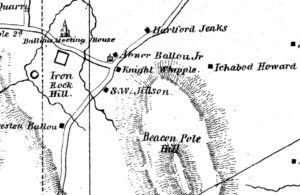
Location: probably the “Ichabod Howard” house on the 1836 map, this was determined by reference to the 1870 map, which shows the location of the house of E. T. Harris.
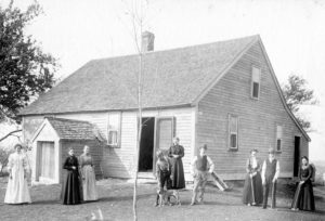
Nathaniel was one of the three Ballou brothers who originally settled in Cumberland. The bulk of Nathaniel’s farm lay “somewhat northeasterly” of Beacon Pole Hill. “The present dwelling house, which is understood to stand nearly on the original site, is about a half a mile easterly of the Ballou meeting house and one fourth of a mile, in the same direction from the residence founded by James Ballou.”
“It was called for many years the Jillson place, and is now occupied by Eliab T. Harris.” It is also described as being built on the northerly slope of Beacon Pole Hill. [1]
Nathaniel died intestate, and his estate went to his son Amariah, who carefully executed deeds to his two brothers, Noah and Stephen, for “brotherly affection”, giving them equal shares with himself. He kept the family home until 1771, when he sold it to his cousins, Reuben and Asa Ballou, and moved to Massachusetts. It was afterwards purchased by Rev. Abner Ballou, who gave it to his grandson, Welcome Jillson, who died in 1807. By the 1880’s, the time of the “Elaborate History”, it was owned by Eliab T. Harris.
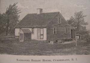
The illustrations of this house and of the James Ballou house in the “Elaborate History” identified these pictures in the album.
- “An Elaborate History”, p. 43-44.
- Atlas of the State of Rhode Island and Providence Plantations, p.47. Compiled and Published by D. G. Beers & Co., Philadelphia, 1870